Non-Destructive & Fast
No holes, no excavation, no disruption. A typical residential lot survey takes a half-day. Pavement networks cover thousands of linear feet per day. Active warehouses keep running while we work.
Void Detection · Utility Locating · Concrete Scanning
Professional GPR in Florida — sinkhole screening, utility locating, void detection, concrete scanning, pavement layer evaluation. Engineering-interpreted, not just raw data. Call (352) 619-9292.
Non-Destructive Subsurface Imaging · Engineering-Interpreted
GPR is a great first move. It’s a terrible last move. We use it where it shines — sinkhole screening, utility locating, void detection, concrete scanning — and we tell you the limitations before they bite you.
No holes, no excavation, no disruption. A typical residential lot survey takes a half-day. Pavement networks cover thousands of linear feet per day. Active warehouses keep running while we work.
Anybody can buy a GPR cart. The value is in reading the radargram — knowing what reflection patterns mean in Florida geology, and when an anomaly warrants drilling vs. when it doesn’t.
For sinkhole work, foundation siting, or anything that ends up in a stamped report, GPR points to where to drill — and we drill there. Same firm, same engineer, no integration headaches.
Ground-penetrating radar doesn’t see what’s down there. It sees the boundary between things that are down there. That distinction matters — and most of the marketing for GPR services skips over it.
What GPR actually does is send a short pulse of electromagnetic energy into the ground and listen for what bounces back. When the pulse hits a boundary between materials with different dielectric properties — soil-to-rock, soil-to-void, concrete-to-rebar, native-to-pipe — some energy reflects back to the antenna. The arrival time and shape of the reflection produce a two-dimensional cross-section as the antenna moves across the surface. That’s a radargram. It’s powerful, it’s fast, and it’s continuous — far more continuous than borings can be.
It’s also limited. Conductive soils — wet clays, saltwater-saturated coastal soil — attenuate the signal so fast you can barely see ten feet down. Even in good Florida sand, useful depth tops out around 15–20 feet for low-frequency antennas. And the radargram doesn’t tell you what the materials are, only that there’s a boundary. That’s where the engineer comes in. FGS deploys GPR where it actually answers the question, integrates it with borings where confirmation is needed, and tells you when GPR isn’t the right tool for what you’re trying to do.
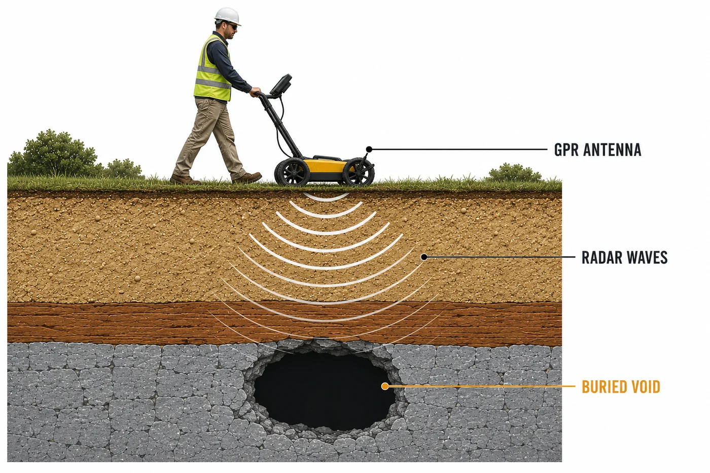
The antenna pulses electromagnetic energy into the ground at a chosen frequency. Lower frequencies (100–400 MHz) penetrate deeper but with less resolution — they’re what we use for sinkhole work, deep void detection, and locating utilities that are buried four or five feet down. Higher frequencies (900 MHz to 2.6 GHz) trade depth for resolution — those are the antennas we put on a hardhat and scan a concrete slab with to locate rebar and post-tensioning before cutting.
The depth calculation depends on the dielectric constant of the soil — which varies with type, moisture content, and clay content. In dry Florida sand, the wave speed is fast and the depth conversion is clean. In wet clay, signal energy bleeds away rapidly and the antenna sees less. Saturated coastal soil with brackish water in the pores is just about the worst case for GPR. Knowing those limits before you send a crew out is part of the job.
GPR is a screening and locating instrument. The applications below are where it consistently delivers value — and where most Florida projects benefit from putting a radar antenna on the site before anyone breaks ground.
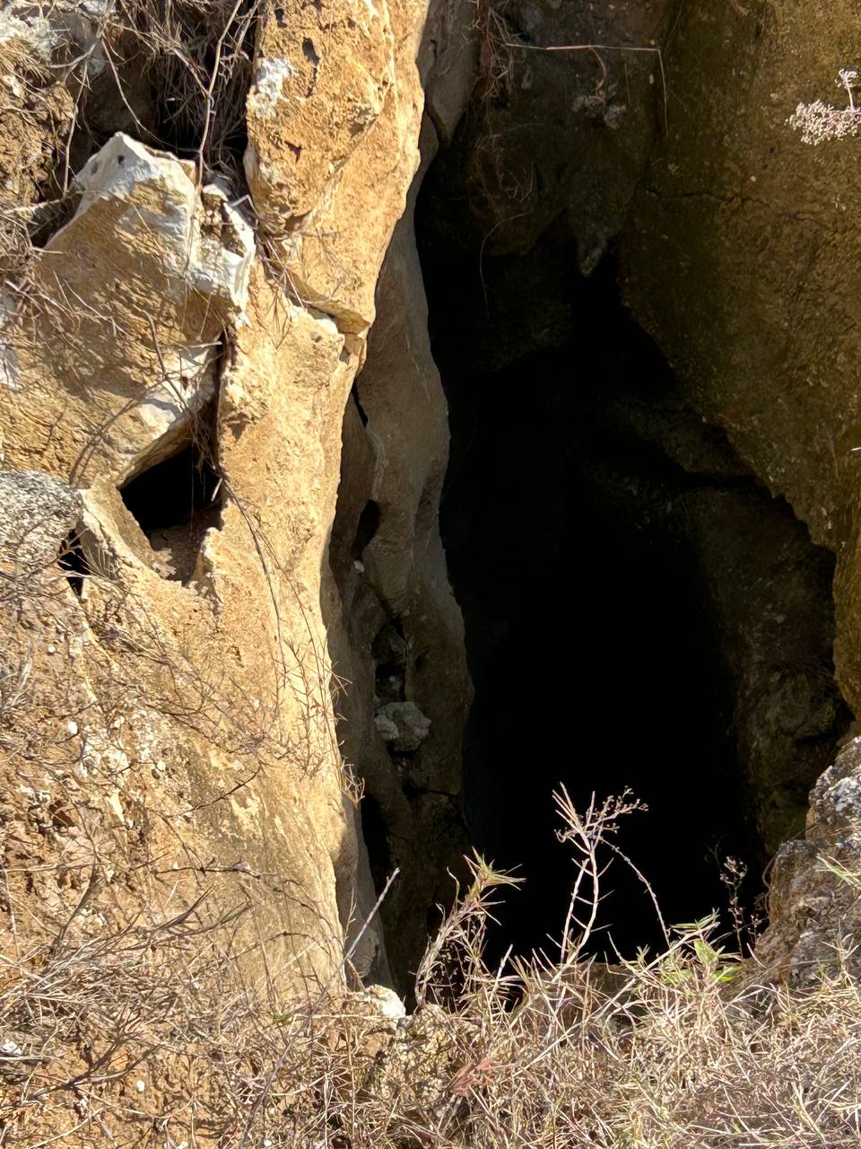
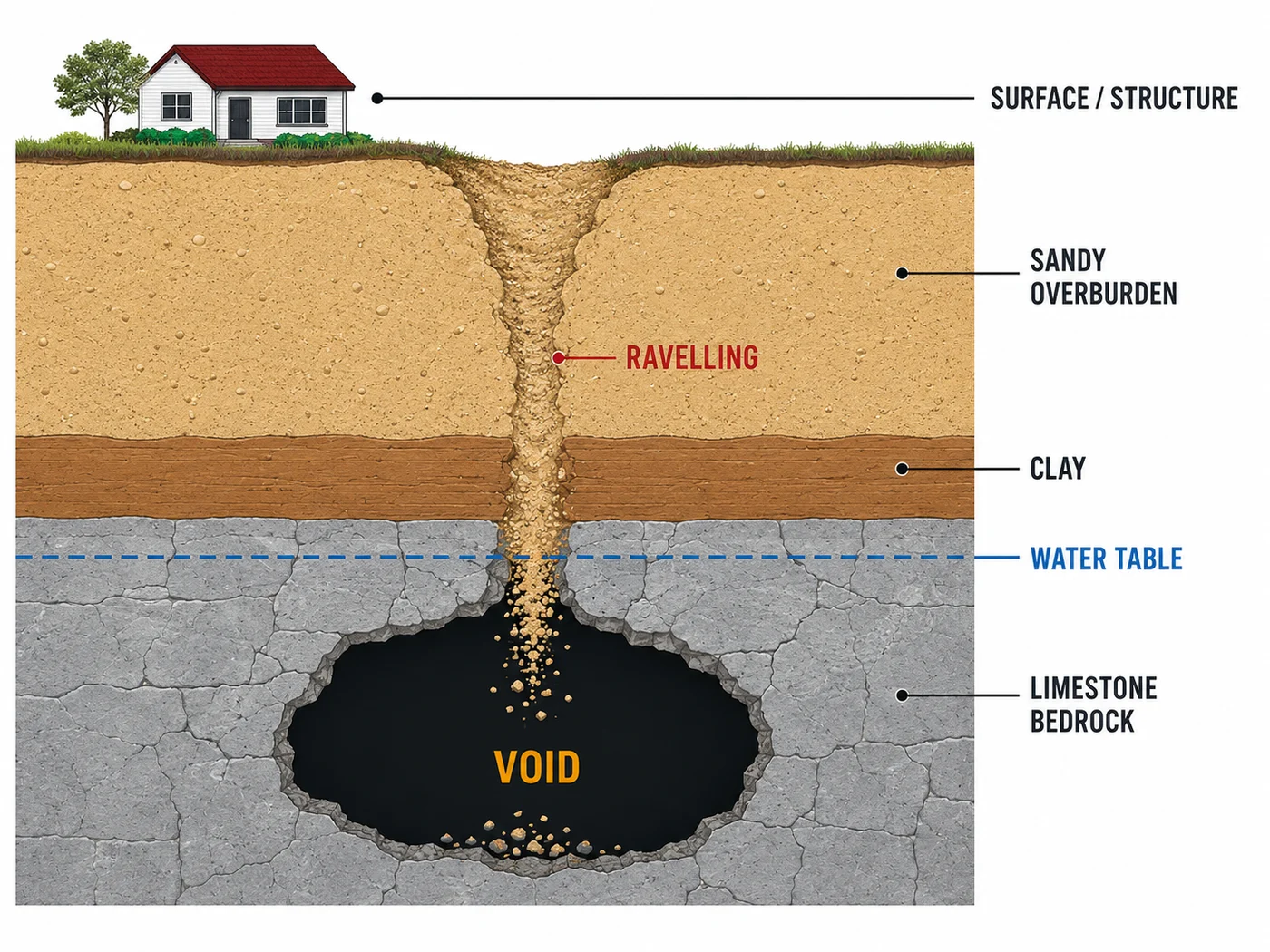
The first move in any karst-aware investigation. GPR identifies voids, raveling zones, pinnacled rock surface, and overburden anomalies fast. Then we drill where the GPR points us instead of guessing on grid spacing. Sinkhole evaluations →
Sunshine 811 mark-outs miss private utilities. Old as-builts lie. Non-metallic pipe (PVC, HDPE, concrete) is invisible to conventional electromagnetic locators but visible to GPR. Grid surveys produce a real subsurface utility map before excavation starts.
Voids under concrete from soil piping, sinkhole raveling, broken drain lines, or settled fill. Warehouse floors, parking structures, bridge decks. We scan, locate, and document the voids before they turn into a slab failure.
Locate rebar, post-tensioning tendons, conduit, and voids inside concrete before cutting or coring. Measure pavement layer thicknesses across miles of roadway without coring every hundred feet. Pavement evaluation →
Every tool has limits. With GPR, the four big ones to know up front:
Conductive soils kill the signal. Clay-rich and saltwater-saturated soils attenuate fast. In coastal areas with high salinity in the pore water, GPR might see five feet down. We’ll tell you that before we mobilize, not after.
Depth limits. Practical investigation depth in Florida sand is 15–20 feet with low-frequency antennas. Features deeper than that need other geophysical methods (electrical resistivity, seismic) or direct drilling.
Skilled interpretation required. A radargram is not a photograph. Reflection patterns can come from multiple sources. Misreading anomalies as sinkholes — or missing real ones — happens when untrained operators try to interpret data they don’t fully understand.
No direct material identification. GPR shows a boundary; it doesn’t tell you what’s on either side. For sinkhole confirmation, foundation siting, or anything stamped, borings remain the definitive method. GPR tells you where to drill.
Knowing these limits is the difference between a useful GPR survey and an overconfident one. Anybody who tells you they did a sinkhole evaluation with GPR alone is overselling. Anybody who claims GPR can see through wet clay to 50 feet hasn’t run enough surveys.
GPR rarely stands alone. The way we use it is as part of a larger investigation chain:
GPR first, then targeted SPT borings, then rock coring, then lab. Each step ground-truths the one before it. Full sinkhole methodology →
GPR supplements boring data to catch what individual borings might miss between drill locations. Foundation engineering →
GPR locates buried tanks, abandoned utility lines, and underground vaults before sampling. ESA services →
GPR measures continuous layer thicknesses to support overlay design and pavement management. Pavement design →
Often standalone, often urgent, always before the backhoe shows up.
Same firm, same engineer, same chain of custody from field through report. The GPR data, the boring data, and the engineering analysis all live under one stamped report — instead of three separate documents from three firms that don’t quite agree.
Sinkhole concern, utility locate, void detection, concrete scan, pavement layer thickness — describe what you’re after and we’ll tell you whether GPR is the right tool. And if it isn’t, we’ll tell you what is.
FAQ
No. GPR is a screening tool. It can identify anomalies that warrant follow-up, but it can't confirm what those anomalies are without ground-truth from borings. Florida Statute 627.707 doesn't accept a GPR-only sinkhole evaluation, and neither does any responsible insurance reviewer or court. Anyone offering a sinkhole report based on GPR alone is selling something other than a defensible investigation.
A quarter-acre residential lot for sinkhole screening — about a half-day in the field. A commercial site or roadway corridor with a denser grid — one to several days. Concrete scanning of a specific slab area can sometimes be done in a couple of hours. We give project-specific scheduling estimates during the proposal phase based on the actual scope.
Yes — and this is one of the better reasons to use GPR. Conventional electromagnetic pipe locators only detect metallic and traceable utilities. GPR detects non-metallic utilities (PVC, HDPE, concrete pipe) based on their dielectric contrast with the surrounding soil — air-filled or water-filled non-metallic pipes show up well. For pre-excavation utility surveys where private or non-metallic utilities are suspected, GPR is the right tool.
It happens. Saturated clayey soil, deep targets, or sites with heavy electromagnetic interference can render GPR ineffective. When we suspect those conditions before mobilization, we say so up front — we'd rather lose the GPR scope than charge for data we can't use. Alternative methods (electrical resistivity tomography, seismic refraction, or just direct drilling) exist for the cases where GPR doesn't fit. We'll recommend the right tool, not just the tool we have.
A written report with the survey methodology, antenna specifications, interpreted findings, and annotated radargrams illustrating key features. For utility surveys, a scaled plan view of located utilities. For sinkhole work, the GPR report integrates with boring logs and engineering analysis into a single comprehensive geotechnical report under a P.E. seal. We don't just hand over raw radargrams; we hand over an interpretation a project engineer can actually use.
Get started
Tell us about your project and we'll get right back to you. Industry-leading turnaround on stamped reports, fieldwork, and lab results.
Prefer to talk? (352) 619-9292
Thanks — we've got it and we'll be in touch within one business day.
Need it now? Call (352) 619-9292.
Statewide service area
FGS delivers ground penetrating radar across Central and North Florida from our Ocala lab. Explore the service in the communities we cover most: